Emergency response operations are bound by a rigid physical constraint: the time-space friction of ground transit. When a 911 dispatch alerts emergency services to an active crisis, every second before intervention exponentially degrades survivability, particularly in time-sensitive environments like aquatic distress. Traditional response frameworks rely on vehicles navigating urban congestion, introducing variable latency that compromises tactical outcomes.
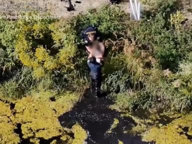
The deployment of automated, docked aerial assets by the St. Paul Police Department during the rescue of a child from a pond demonstrates a fundamental structural shift in public safety logistics. By removing the vehicle from the physical flow of traffic through remote deployment, agencies can compress the critical window between distress detection and situational assessment. This analysis deconstructs the operational mechanics, economic trade-offs, and systemic bottlenecks governing automated aerial first response.
The Operational Mechanics of Response Latency
To understand the efficacy of an aerial response asset, emergency logistics must be broken down into distinct temporal components: dispatch processing time, transit time, and acquisition time.
In a conventional deployment model, an officer receives a call, enters a patrol vehicle, and drives to the coordinates. Physical distance and traffic friction dictate transit velocity. Average urban response times regularly span several minutes, during which environmental variables remain uncontrolled.
Conventional Model:  [911 Call] -> [Dispatch] -> [Vehicle Transit (High Latency)] -> [Arrival/Search]
Automated Drone Model: [911 Call] -> [Remote Launch] -> [Aerial Transit (Direct Vector)] -> [Visual Acquisition]
When utilizing a remotely piloted or docked drone program, transit vector constraints change entirely. The aerial asset bypasses ground-level infrastructure barriers, traveling via a direct line of sight at high speeds. In the St. Paul incident, the drone arrived on the scene two full minutes before the first ground units.
This temporal delta alters the entire operational equation. Two minutes of advance arrival means the aerial unit serves as an overwatch platform before tactical ground forces engage. The pilot, operating from a remote command post miles away, can process spatial layouts, identify exact coordinates, and vector officers directly to the target, eliminating the friction of ground-based searching.
The Three Pillars of Aerial Tactical Integration
Integrating unmanned aerial systems into municipal emergency workflows requires balancing three distinct operational pillars: spatial telemetry, communication architecture, and human-in-the-loop decision-making.
1. Spatial Telemetry and Visual Acquisition
Ground visibility in complex environments is severely limited by line-of-sight obstructions, vegetation, and topography. A pond or body of water surrounded by brush creates blind spots for ground units arriving from specific approaches. An aerial asset provides an orthogonal perspective, transforming a blind search pattern into an immediate visual confirmation. High-definition optical telemetry relays exact coordinates, removing ambiguity about whether a subject is actively submerged or on the shore.
2. Communication Architecture and Command Decoupling
Decoupling the sensor platform from the physical ground unit allows for distributed command structures. In the documented deployment, the drone pilot operated from over three miles away while relaying real-time updates to the rescuing officer entering the water. This structure protects cognitive bandwidth on the ground. The officer executing the physical rescue does not need to waste cognitive load scanning or mapping the perimeter; they act strictly on vector data supplied by the remote overseer.
3. Risk Mitigation and Predictive Intervention
In aquatic distress scenarios, physiological failure occurs rapidly. Submersion past critical thresholds shifts the operational objective from a rescue operation to a recovery operation. By cutting response latencies down to under two minutes, aerial assets shift the intervention curve back into the rescue window. The capability to visually confirm an individual's panic state or head submergence allows ground teams to prepare exact extraction protocols before boots touch the ground.
The Cost Function and Policy Friction
Despite the clear operational upside of docked drone programs, municipal scaling faces severe friction, most notably through public policy pushback and privacy concerns. The fundamental tension in modern public safety technology rests on a distinct risk-reward trade-off:
- The Safety Dividend: Immediate deployment of aerial assets saves lives by shortening incident horizons and optimizing officer resource allocation.
- The Privacy Debt: Continuous overwatch capabilities introduce surveillance externalities, prompting municipal legislative bodies to restrict or cap drone expansion due to citizen apprehension.
This creates a governance bottleneck. While police departments view drones as logistical efficiency multipliers, city councils often respond to civil liberty pressures by halting program growth. The systemic failure here is a lack of structured transparency. Agencies that fail to codify strict operational boundaries—such as automated flight path logging, strict data retention limits, and restriction to active 911 dispatch triggers—will continuously encounter legislative resistance.
Strategic Operational Forecast
The integration of automated aerial response units represents an irreversible evolution in emergency services, but its trajectory depends entirely on how agencies manage public trust. Municipalities can no longer rely solely on the moral weight of a successful rescue to justify infrastructure expansion.
To scale these programs past legislative friction, police administrators must treat drone deployment not as a surveillance expansion, but as a precision emergency medical service analogous to an automated external defibrillator. The focus must shift toward hard data metrics: measuring response time compression, tracking resource expenditure per incident, and quantifying lives preserved within the critical sub-four-minute window.
Establish explicit operational governance protocols that restrict drone deployment strictly to verified high-priority 911 dispatches, ensuring the technology functions as a life-saving intervention tool rather than a generalized monitoring grid.