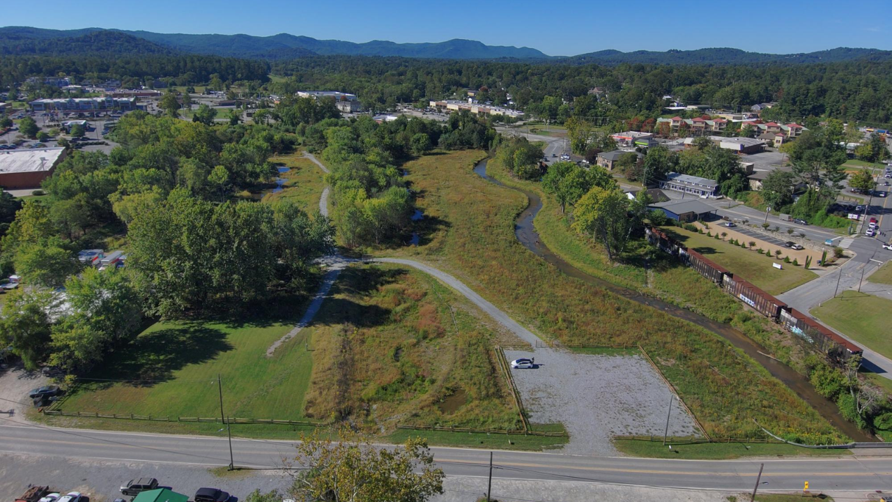
Restoring 27 acres of urban wetlands to insulate 93 vulnerable properties from flood damage establishes a direct operational ratio of 3.44 protected structures per acre of rehabilitated ecological infrastructure. Municipalities across North Carolina face escalating stormwater management liabilities driven by rapid impervious surface expansion and intensifying precipitation events. Rather than relying exclusively on high-maintenance concrete conveyance systems—which merely accelerate runoff downstream—this capital allocation demonstrates how green infrastructure functions as a distributed hydraulic buffer. By converting degraded urban acreage back into functional floodplains, municipal planners trade high recurring capital expenditures for self-sustaining hydrological retention.
Standard municipal reporting treats wetland restoration as a passive environmental amenity rather than a calculable civil engineering asset. To evaluate the true return on investment of a 27-acre intervention, analysts must dissect the physical mechanics of stormwater attenuation, the financial exposure of the 93 downstream parcels, and the structural limitations of biological flood control.
The Hydraulic Mechanics of Stormwater Attenuation
When rain falls on an undeveloped watershed, soil porosity and root networks intercept, infiltrate, and evapotranspire the majority of the volume. Urbanization replaces this permeable matrix with asphalt, concrete, and compacted fill. Under these altered conditions, the runoff coefficient—the ratio of surface runoff to total rainfall—spikes from roughly 0.15 in forested terrain to over 0.85 in dense commercial or residential zones. Stormwater reaches peak discharge velocity within minutes rather than hours, overwhelming legacy storm drains and forcing water into adjacent structures.
A 27-acre wetland restoration reverses this hydraulic compression through three distinct physical mechanisms.
Volumetric Storage Capacity
Excavating compacted urban fill and re-establishing micro-topography creates physical basin volume. One acre of wetland holding an average water depth of just one foot retains 325,851 gallons of water. Across 27 acres, a conservative one-foot inundation profile captures 8.79 million gallons of stormwater during a single precipitation event. Deeper engineered pools within the wetland complex expand this holding capacity exponentially, removing millions of gallons from the immediate downstream flood wave.Hydraulic Roughness and Peak Flow Attenuation
In fluid dynamics, Manning's roughness coefficient measures the friction a surface exerts on flowing water. Smooth concrete pipes have a low roughness coefficient (approximately 0.012), maximizing water velocity. Dense wetland vegetation—sedges, rushes, and woody shrubs—exhibits a high roughness coefficient (ranging from 0.050 to 0.150). This biological friction slows sheet flow, flattening the hydrograph—the graph plotting water discharge rate against time. Instead of a catastrophic spike that breaches banks and floods foundations, the wetland releases the stored volume gradually over days after the storm passes.Subsurface Infiltration and Baseflow Recharge
Healthy wetland soils contain high concentrations of organic matter that act as a sponge, drawing surface water into the shallow water table. This vertical percolation reduces total surface volume while replenishing local aquifers, stabilizing stream baseflows during subsequent dry periods.
Deconstructing the Ninety-Three Property Exposure Profile
Protecting 93 properties with a single 27-acre footprint requires precise spatial targeting within the watershed. In urban hydrology, flood risk is rarely distributed evenly; it concentrates in low-lying alluvial corridors, historic creek beds that were culverted during mid-twentieth-century development, and downstream bottlenecks where drainage infrastructure narrows.
To isolate and shield these specific parcels, civil engineers map the drainage area ratio—the total upstream acreage feeding runoff into the restoration site. If a 27-acre wetland sits at the base of a 500-acre urbanized sub-basin, it acts as a choke point that intercepts runoff from nearly twenty times its own surface area. The 93 protected properties sit directly within the hydraulic shadow of this choke point.
The financial exposure of these 93 parcels encompasses several compounding liabilities:
- Direct Structural Damage: Water intrusion destroys drywall, electrical systems, HVAC units, and foundation integrity. Under National Flood Insurance Program (NFIP) actuarial tables, just one inch of floodwater in an average single-family home generates tens of thousands of dollars in structural and personal property losses.
- Repetitive Loss Designation: Properties subjected to recurring nuisance flooding enter a cycle of escalating insurance premiums and declining appraised values. When a neighborhood becomes categorized as a repetitive loss cluster, municipal property tax revenues erode alongside private equity.
- Municipal Emergency Response Costs: Every flood event triggers direct public expenditures, including swift-water rescues, road closures, debris removal, and emergency utility repairs.
By intercepting the flood wave upstream of these 93 structures, the 27-acre project shifts the financial equation from recurring post-disaster payouts to a single, front-loaded capital investment.
Capital Allocation Framework Gray vs Green Infrastructure
Municipal public works departments traditionally default to gray infrastructure—larger reinforced concrete pipes, deeper retention vaults, and channelized concrete ditches—to solve localized flooding. This preference stems from predictable engineering tolerances and familiar contractor workflows. However, gray infrastructure carries severe structural drawbacks when scaled across aging North Carolina cities.
First, gray infrastructure is monofunctional. A 72-inch concrete storm pipe performs zero utility during dry weather. Second, gray systems suffer from linear depreciation. Concrete spalls, joints separate, and pipes silt up, requiring massive capital infusions every 30 to 50 years for excavation and replacement. Third, gray infrastructure transfers risk rather than eliminating it. Widening a culvert to drain one neighborhood faster simply pushes a larger, faster wall of water onto the next neighborhood downstream.
Green infrastructure—specifically large-scale wetland restoration—operates under a different economic model.
- Appreciating Functional Capacity: Unlike concrete, which degrades from the day it is poured, a restored wetland increases in hydraulic efficiency over its first decade. As root systems deepen and soil organic matter accumulates, infiltration rates and roughness coefficients improve naturally.
- Co-Benefit Monetization: While protecting the 93 properties provides the primary economic justification, the 27-acre asset simultaneously filters non-point source pollutants—trapping nitrogen, phosphorus, heavy metals, and hydrocarbons before they enter major river basins. This water quality improvement helps cities meet federal Clean Water Act mandates and Total Maximum Daily Load (TMDL) limits without building expensive chemical treatment plants.
- Heat Island Mitigation: Replacing impervious surfaces or degraded vacant lots with vegetated wetlands lowers ambient air temperatures in surrounding urban blocks through evapotranspiration, reducing peak summer energy demand for adjacent residents.
Execution Architecture of an Urban Wetland Restoration
Converting 27 acres of urban land into a functional flood-attenuation basin demands rigorous civil and ecological engineering. It is not a passive landscaping exercise; it requires heavy earthmoving and precise hydrological calibration.
Phase One Land Assembly and Site Assessment
Urban land is fragmented. Assembling 27 contiguous or hydrologically connected acres often involves acquiring brownfields, defunct industrial parcels, or flood-prone residential lots through voluntary buyouts. Engineers conduct soil borings to identify legacy contamination, map buried utilities, and locate the historic hydric soil layer buried beneath decades of urban fill.
Phase Two Mass Grading and Hydrological Reconnection
Heavy machinery removes non-native fill dirt to lower the site elevation back to the natural water table. If an adjacent stream was previously channelized and incised—cut deep into the earth like a ditch—engineers raise the streambed or breach its artificial levees. This reconnects the waterway to its historic floodplain, allowing high flows to spill naturally across the 27-acre basin rather than remaining trapped in a high-velocity channel.
Phase Three Micro-Topography and Soil Amendment
Engineers sculpt the graded basin with varied elevations: deep pools for permanent water retention, shallow marshes for emergent vegetation, and slightly elevated hummocks for woody shrubs. Compacted subsoils are ripped and amended with organic compost to restore porosity immediately, preventing early storm events from scouring the bare earth.
Phase Four Native Flora Establishment and Invasive Suppression
The site is planted with a dense matrix of native hydrophytic species adapted to North Carolina's specific piedmont or coastal plain climate. These plants must survive both prolonged inundation during hurricane season and extended summer droughts.
Operational Limitations and Engineering Constraints
Treating wetland restoration as a universal cure for urban flooding leads to critical planning failures. A rigorous assessment must account for the hard physical boundaries of biological systems.
Antecedent Moisture Saturation
A wetland's storage capacity is finite. If a tropical system stalls over North Carolina and drops ten inches of rain over three days, the 27-acre basin will reach full capacity during the first twenty-four hours. Once the soil profile is completely saturated and the surface pools are full, the wetland reaches hydraulic equilibrium: every subsequent gallon entering the site will exit at the exact same rate. Under extreme, multi-day tail-risk weather events, downstream properties still require secondary protections such as elevated foundations or localized floodwalls.Spatial Scarcity and Land Acquisition Costs
In dense urban cores, assembling 27 acres of open land is frequently cost-prohibitive or physically impossible due to existing commercial development. When land costs exceed civil engineering budgets, municipalities must pivot to decentralized micro-interventions—bioswales, permeable pavement, and underground retention vaults—despite their lower hydraulic efficiency per dollar spent.The Establishment Lag Phase
A newly graded wetland is structurally vulnerable for its first two to three growing seasons. Until root mats lock the soil in place, an intense convective thunderstorm can erode freshly graded banks, transport sediment downstream, and uproot newly planted vegetation. Municipalities must budget for active adaptive management during this window, including replanting, sediment removal, and aggressive eradication of invasive species like Phragmites australis or kudzu that outcompete native flood-attenuating flora.Upstream Sediment and Trash Loading
Urban runoff carries high loads of coarse sediment, plastics, and chemical runoff. Without a dedicated forebay—a sacrificial, easily accessible settling basin at the inlet of the wetland—trash and silt will rapidly fill the main wetland pools, reducing volumetric storage capacity and smothering native plant beds.💡 You might also like: Why the Beijing Trump Putin Leak is Diplomatic Theater for the Naive
Strategic Imperatives for Municipal Infrastructure Planners
The 27-acre restoration protecting 93 properties establishes a replicable benchmark for urban resilience, provided municipal leaders integrate ecological engineering into their core capital improvement plans rather than treating it as an isolated grant-funded experiment.
To replicate and scale this operational ratio across other vulnerable watersheds, public works departments and city councils must execute four concrete adjustments:
- Mandate Benefit-Cost Ratios Over Least-Cost Bidding: Municipal procurement rules typically favor the lowest upfront construction bid, which artificially skews selection toward gray infrastructure. Cities must adopt lifecycle accounting models that factor in 50-year maintenance liabilities, avoided flood damage across specific parcel counts, and water quality compliance credits.
- Target Repetitive Loss Clusters for Upstream Buyouts: Instead of spending federal hazard mitigation grants solely on elevating individual homes in isolation, planners should map the upstream drainage basins feeding those clusters and aggressively acquire degraded commercial or vacant parcels to build centralized attenuation wetlands.
- Designate Forebays as Mandatory Maintenance Infrastructure: Every urban wetland project must include paved access roads and hardened forebays at stormwater inlets, funded through dedicated stormwater utility fees so public works crews can dredge accumulated urban sediment on a strict annual schedule.
- Integrate Real-Time Hydrological Telemetry: Deploy automated water-level sensors and flow meters at the inlets and outlets of restored wetlands. Quantifying the exact cubic feet per second of peak flow reduction during live storm events generates the empirical actuarial data required to lower community-wide flood insurance rates under FEMA's Community Rating System.


