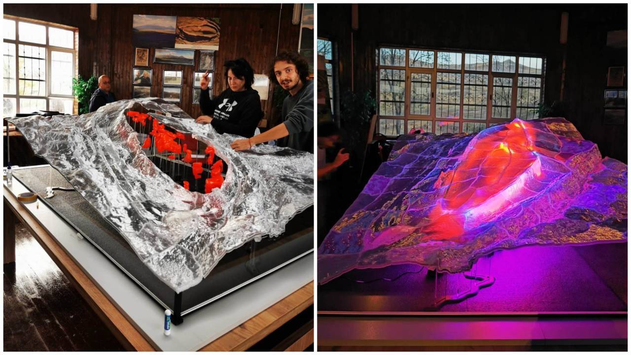
A 3D-printed model of Turkey's roughly 157-metre Durupinar formation does not prove Noah's Ark lies buried near Mount Ararat, even after crews drilled more than 60 feet underground and released images of charred wood. What the plastic topography actually reveals is a collision between aggressive fundraising optics, early-stage subsurface sampling, and decades of unresolved geological skepticism.
I have watched fringe archaeology cycles repeat for thirty years in dusty press rooms and conference halls. Usually, someone points to a satellite photo, invokes a biblical measurement, and sells hope by the crate. This time, the operators behind Noah's Ark Scans—working alongside Turkish archaeologist Prof. Dr. Cenker Atila under an authorized research plan in Ağrı Province—moved past passive observation and put steel into the dirt.
Drilling changes the stakes. Talk is cheap when nobody can touch what is beneath the crust. Once cores come up and plastic models hit social feeds, every claim faces a harder test: whether an anomaly reflects a human-built vessel or simply rock, mudflow, and tectonic stress behaving the way rock always behaves.
What the 3D Model Actually Shows
Strip away the dramatic lighting and social media captions, and a 3D-printed model is a translation of data, not an X-ray of history. Ground-penetrating radar, electrical surveys, and elevation scans measure differences in how waves reflect or resist underground materials. Turning those readings into physical ridges, layers, and colored void markers creates an object anyone can hold in their hands.
Tactile objects are persuasive. A physical model lets a viewer trace a hull-like curve or point at an internal pocket without ever reading a raw geophysical profile. That accessibility is precisely why teams print them. It bridges the gap between dense subsurface datasets and public curiosity.
Yet visualization is an interpretation step, not proof of origin. Subsurface voids in eastern Turkey can stem from dissolved minerals, buried boulders, shifting sediment pockets, or old landslide debris. A bump on a 3D print tells you a signal changed at a certain depth. It cannot tell you whether a carpenter laid a beam or a mountain slipped ten thousand years ago.
Drilling Deep Where Talk Once Ruled
For decades, arguments around the Durupinar site leaned heavily on surface shape and cubit math. Believers pointed to its boat-like outline and roughly 157-to-164-metre span as a match for ancient descriptions of an ark. Mainstream geologists countered that ancient cubits varied widely by region and era, and that nature routinely carves elongated mounds out of active fault zones and sloping terrain.
The 2026 field push shifted the argument toward physical extraction. Crews conducted core drilling past 60 feet deep, reported shattered drill bits against hard material, and later circulated video showing charred wood fragments pulled from roughly nine metres down on the southern slope. Team members suggested some material showed signs of shaping or tool work and pointed toward winter laboratory testing for organic content, microscopy, and mineralogy.
A drill bit breaking or a dark fragment emerging from a borehole is an event, not a verdict until independent labs establish age, context, and origin.
Hard layers stop drill bits every day in ordinary civil engineering. Dense mineral concretions, welded volcanic ash, or silicified rock can chew up steel quickly. Likewise, finding charred or weathered wood in a geologically active region demands strict provenance checks. Wood can wash into slope deposits, burn in ancient ground fires, or come from later human activity far removed from any primordial flood.
Hypothetically speaking, imagine a contractor bores into an urban hillside and pulls up a blackened plank beside a hollow pocket. Without radiocarbon dates, stratigraphic context, and peer-reviewed mineral analysis, you still have an intriguing sample—not an answered history question. The same discipline applies in Ağrı Province.
Science Versus Spectacle in the Field
One glaring tension runs straight through this campaign. Careful field researchers talk about winter lab screening, microscopy, and testing competing hypotheses. Fundraising messaging, by contrast, frequently frames the work as an imminent takedown of evolutionary biology and established science.
That split creates real credibility friction. Serious earth scientists judge claims by repeatable measurements, blind controls, and published stratigraphy. When public announcements promise curriculum-shattering revolutions before laboratory results are even completed, skeptical researchers tune out before looking at the data.
Consider the difference between two ways of presenting the exact same borehole:
| Aspect | Lab-First Approach | Spectacle-First Approach |
|---|---|---|
| Primary Goal | Test geological vs. human origins rigorously | Build donor momentum and viral reach |
| Treatment of Anomalies | Treated as hypotheses requiring verification | Framed as near-proof of a buried vessel |
| Role of 3D Models | Spatial aid for mapping survey zones | Eye-catching centerpiece for media coverage |
| Timeline to Proof | Waits for lab assays and independent review | Peaks during drilling and social releases |
Neither approach stops the clock on winter testing. Real answers will come from what sits inside sealed sample bags, how surrounding sediments sit above and below them, and whether independent specialists can examine the findings without gatekeeping.
What It Takes to Move Past Speculation
Anyone following the Durupinar story should separate visual drama from verifiable evidence. A 3D-printed model can help a team explain where they scanned and drilled, yet it cannot settle a dispute that has divided commentators for more than sixty years.
Watch for concrete laboratory benchmarks rather than bold slogans. Credible progress requires clear dating methods where applicable, mineralogical comparisons with surrounding formations, and microscopic checks that distinguish natural fractures or decay from deliberate craftsmanship.
Until peer-scrutinized lab results are published and tested against local geology, the 157-metre mound remains what it has been all along. It is a striking physical feature in eastern Turkey with a newly drilled record—and an unproven story waiting for hard evidence.