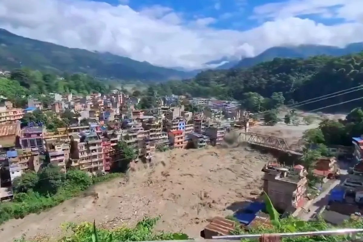
Understanding the mechanics behind extreme hydrological disasters in the Himalayan region requires stripping away emotional narratives to examine the exact physical vectors of failure. When extreme precipitation events strike topographically volatile zones like Nepal, the resulting devastation is rarely the result of a single isolated meteorological anomaly. Instead, it represents the catastrophic convergence of atmospheric thermodynamics, hydrological saturation thresholds, and systemic infrastructural vulnerabilities.
Evaluating these events through an operational lens exposes the exact failure points that transform seasonal monsoons into high-velocity kinetic hazards. Analyzing the primary drivers requires categorizing the disaster into three distinct functional layers: meteorological catalysts, topographical amplification vectors, and anthropogenic vulnerability multipliers. Learn more on a similar subject: this related article.
The Atmospheric Mechanics of Extreme Precipitation
Severe flash floods in Nepal are fundamentally driven by localized atmospheric stagnation combined with moisture-laden low-pressure systems. During the late monsoon transition periods, low-pressure anomalies often stall over the northern Indian subcontinent, drawing continuous, high-volume vapor streams from the Bay of Bengal directly toward the Himalayan foothills. Further analysis by Associated Press highlights similar perspectives on the subject.
As these saturated air masses encounter the steep orographic barriers of the Mahabharat and Himalayan ranges, they are forced upward rapidly. This forced adiabatic cooling triggers intense, concentrated condensation. Precipitation rates during these cloudburst events frequently exceed standard drainage capacities because the cloud base remains compressed against narrow river valleys.
- Orographic Lifting: Warm, moisture-dense air is rapidly thrust upward by thousands of meters of vertical relief, maximizing precipitation efficiency over hyper-localized catchment areas.
- Atmospheric Blocking: Upper-level jet stream patterns occasionally create blocking highs that trap storm cells over central Nepal, multiplying total precipitation volume over a stagnant geographic footprint.
- Thermal Convection Loops: High ambient baseline temperatures in the lower valleys increase the moisture-holding capacity of the air, ensuring that when cooling does occur, the volumetric release of water is extreme.
Topographical and Hydrological Amplification Vectors
The physical layout of Nepal acts as a natural funnel, turning dispersed rainfall into concentrated kinetic energy. The country features an extreme altitudinal drop over a remarkably short horizontal distance, creating steep river gradients that accelerate runoff velocity exponentially.
When extreme rainfall occurs, the time of concentration—the time required for water from the furthest point of a watershed to reach a common outlet—drops to a fraction of normal expectations. Small tributaries swell simultaneously, causing synchronized flood peaks when they hit main river channels like the Bagmati or the Koshi.
Soil mechanics play an equally critical role. The topsoil across much of the middle hills consists of fragile, weathered rock and loose sediment. Once antecedent soil moisture reaches 100 percent saturation, the shear strength of the slope materials collapses. This transition converts a standard surface water runoff event into a debris-laden mudflow or landslide dam-break wave. A landslide blocking a narrow gorge creates a temporary reservoir that eventually fails catastrophically, releasing an unmanaged wall of water and sediment downstream.
The Urban and Structural Vulnerability Multiplier
Natural hydro-meteorological hazards turn into humanitarian disasters due to systemic friction within human infrastructure. Rapid, unregulated urbanization across the Kathmandu Valley and surrounding river corridors has systematically erased natural retention basins, wetlands, and floodplains.
Impermeable surfaces such as asphalt, concrete, and dense residential construction prevent natural groundwater infiltration. Runoff coefficients in these urbanized catchments approach absolute maximums, meaning nearly 100 percent of rainfall immediately enters the drainage network.
- Encroachment on Riparian Zones: Informal and formal construction directly inside natural riverine buffer zones restricts channel cross-sections, raising water surface elevations during peak discharge.
- Undersized Drainage Architecture: Legacy drainage systems are typically engineered for historical 10-year or 25-year return period storms, rendering them utterly inadequate for modern high-intensity, short-duration precipitation events driven by changing climate baselines.
- Deforestation and Land-Use Change: The conversion of deep-rooted forest cover into terraced agriculture or bare ground strips away the root matrix that stabilizes shallow soils, vastly increasing sediment loads in runoff. Higher sediment concentration increases the density of floodwaters, augmenting their destructive kinetic force against bridge piers, retaining walls, and structural foundations.
Mitigation and Structural Intervention Protocols
Addressing recurrent flash flood catastrophes requires moving away from reactive disaster management toward predictive hydrological engineering. Early warning systems must transition from simple rain-gauge thresholds to radar-based quantitative precipitation estimates coupled with real-time hydraulic modeling of river reaches.
Civil defense strategies must enforce strict zoning laws that prohibit permanent structural placement within high-risk hydraulic corridors. Engineering interventions should prioritize distributed retention ponds, check-dams in upper catchments to trap suspended sediment before it gains momentum, and the retrofitting of urban drainage channels to accommodate higher baseline discharge volumes. Without re-engineering the relationship between human settlement patterns and natural water flow dynamics, hydrological disasters will continue to extract an escalating toll.



